Showing posts with label Environment - Climate Change - Bush Fires. Show all posts

Sunday, 11 January 2026

Environment - Bushfires can create weather


When bushfires make their own weather

Jason Sharples, UNSW Sydney; Andrew Dowdy, The University of Melbourne; Luke Burgess, The University of Melbourne, and Todd Lane, The University of Melbourne

Bushfires are strongly driven by weather: hot, dry and windy conditions can combine to create the perfect environment for flames to spread across the landscape.

But sometimes the relationship flips: fires can generate their own weather systems, which can then dramatically alter the spread and intensity of the blaze.

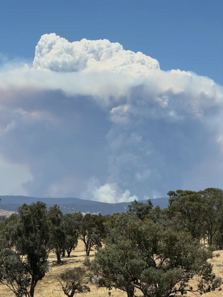
One of the most striking examples of this phenomenon is the formation of pyrocumulonimbus clouds — towering storm clouds born from fire.

How can a fire make winds and clouds?

Large bushfires release enormous amounts of energy – sometimes comparable to that emitted from a nuclear bomb. This heats the air in the vicinity of the fire, causing it to rise rapidly in a powerful, buoyant, fire-driven updraft.

Surrounding air rushes in at ground level to replace the rising hot air, feeding the fire with oxygen like a bellows and sometimes accelerating its spread. In extreme cases, the fire and its induced winds can become a self-sustaining system, feeding and growing from the weather it creates.

If the plume rises high enough it can cool to a temperature where the water vapour in the plume will begin to condense into clouds. This is essentially the same process that leads to the formation of ordinary cumulus clouds, except it occurs within a fire’s plume and is called pyrocumulus.

figure showing different types of cloud.
The classic types of cloud. Pyrocumulus and pyrocumulonimbus are much like their ordinary namesakes, but generated by fire. Valentin de Bruyn/Wikimedia, CC BY-NC-ND

Fire-generated thunderstorms

If the fire is large and intense enough, the plume can keep rising. As the cloud rises above altitudes of around 3–5 kilometres, temperatures can drop well below freezing. Water droplets freeze into ice crystals, releasing another burst of latent heat that further energises the rising plume.

The rapidly rising plume now contains ice and supercooled water — a mixture that is key to thunderstorm-like processes. It is through this process that a fire-generated thunderstorm is born, a pyrocumulonimbus cloud.

Pyrocumulonimbus clouds can reach altitudes of 10–15 kilometres, penetrating the stratosphere.

A pyrocumulus grows over the Mount Lawson fire.
A pyrocumulus grows over the Mount Lawson fire. Satchandcogallery/Facebook

Inside them, strong vertical motions generate turbulence, with ice and water droplets colliding and causing the separation of electrical charges. This can result in lightning, often striking far from the original fire front and in some cases igniting new fires.

These clouds can rise so high that they leave a clear signature visible by satellite, including a long shadow cast over the rest of the cloud and smoke. The first pyrocumulonimbus for this summer may have happened yesterday near the border of NSW and Victoria.

Lightning was detected nearby but this was among lightning occurring in many places across the Southeast states, so it may have just been pyrocumulus clouds, which can still present a significant threat. For example, the deadly 2019 Jingellic fire, which produced tornadic winds, developed a towering pyrocumulus but not a pyrocumulonimbus.

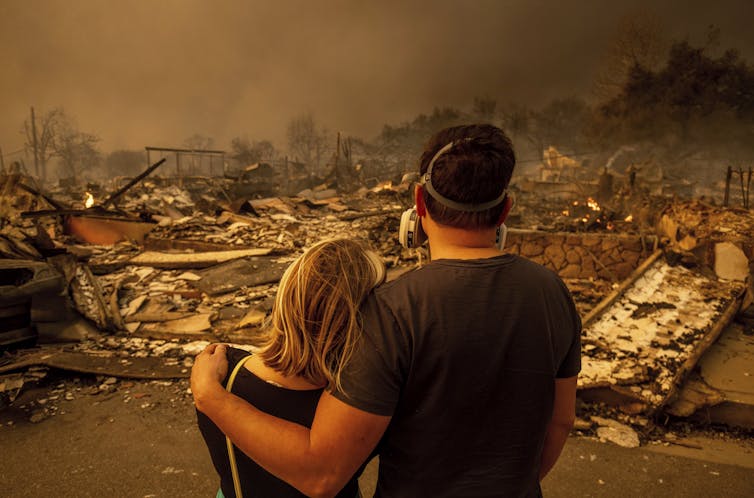
The strong updrafts created by pyrocumulonimbus can cause gusty conditions accelerating fire spread and making it less predictable. The storm can produce a strong updraft bringing fresh air in underneath to the fire, while flinging burning embers over 40km potentially creating new fires. At the same time, strong downdrafts created by the storm can flatten trees and create dangerous conditions for firefighters.

When does this happen?

Not every bushfire spawns its own weather. Pyrocumulonimbus formation requires a delicate balance between the size and intensity of the fire and the stability of the atmosphere.

Firstly, the fire must be large and intense enough to release massive amounts of heat. Secondly, the surrounding atmosphere needs to be suitably conducive to vertical motion. Both of these together allow for the plume to rise.

Satellite photo showing a plume of smoke
Smoke plumes from bushfires in Victoria, January 2025. NASA

Third, moisture in the mid-levels of the atmosphere can enhance the chances of pyrocumulonimbus formation. Moist mid-level air can get caught up in the rising plume and then add to latent heat release when it condenses and freezes, which keeps the plume rising.

The future of fire and thunder

Fire-generated thunderstorms were practically unheard of a few decades ago, but they appear to be becoming more common.

One notable example is the unprecedented number that occurred during the Black Summer of 2019–2020. Other outbreaks include around Melbourne in the Black Saturday fires of 2009 and the Canberra fires in 2003.

In all of those cases, the thunderstorms were so intense they injected smoke into stratosphere, where it circled the Earth and affected global climate patterns. Other examples of extreme weather they can cause include fire-generated tornadoes, as well as black hail in the Canberra fires.

Human-caused climate change has already caused more dangerous weather conditions for bushfires for many regions of Australia, including more dangerous conditions for fire-generated thunderstorms.

Observations show more dangerous conditions are now occurring during summer and also with an earlier start to the fire season, particularly in parts of southern and eastern Australia. These trends are very likely to increase into the future, with climate models showing more dangerous weather conditions for bushfires and fire-generated thunderstorms due to increasing greenhouse gas emissions.

Why understanding this matters

Understanding how bushfires can create their own weather is crucial for forecasting and emergency response. Traditional fire behaviour models often assume that weather drives fire, but when fires start driving weather, those models can fail.

Incorporating prediction of fire-generated clouds into fire management systems helps authorities anticipate sudden changes in fire intensity and spread. Targeted research incorporating satellite monitoring and advanced atmospheric modelling is now being used to better understand and detect conditions favourable for pyrocumulonimbus formation.

This knowledge allows for better warnings, resource allocation, and strategies to protect lives and property.

Bushfires are no longer just a local hazard — they can become atmospheric engines with global reach.The Conversation

Jason Sharples, Professor of Bushfire Dynamics, School of Science, UNSW Canberra, UNSW Sydney; Andrew Dowdy, Principal Research Scientist in Extreme Weather, The University of Melbourne; Luke Burgess, PhD Candidate, Weather and Fire Extremes, The University of Melbourne, and Todd Lane, Professor, School of Geography, Earth and Atmospheric Sciences; ARC Centre of Excellence for the Weather of the 21st Century, The University of Melbourne

This article is republished from The Conversation under a Creative Commons license. Read the original article.

Friday, 10 January 2025

Los Angeles fires and the Santa Ana winds

 How Santa Ana winds fueled the deadly fires in Southern California

Over 1,000 structures burned in the span of two days, Jan 7-8, 2025, near Los Angeles. AP Photo/Ethan Swope
Jon Keeley, University of California, Los Angeles

Powerful Santa Ana winds, near hurricane strength at times, swept down the mountains outside Los Angeles and pushed wildfires into several neighborhoods starting Jan. 7, 2025. Well over 1,000 homes and several schools had burned by Jan. 8, and at least five people had died. Officials urged more than 100,000 residents to evacuate at the height of the fires, but with the winds so strong, there was little firefighters could do to control the flames.

Jon Keeley, a research ecologist in California with the U.S. Geological Survey and adjunct professor at UCLA, explains what causes extreme winds like this in Southern California, and why they create such a dangerous fire risk.

What causes the Santa Ana winds?

The Santa Ana winds are dry, powerful winds that blow down the mountains toward the Southern California coast.

The region sees about 10 Santa Ana wind events a year on average, typically occurring from fall into January. When conditions are dry, as they are right now, these winds can become a severe fire hazard.

A map shows how the Santa Ana winds blow.


Santa Ana winds blow down the mountains toward the coast, drying and warming as they descend. USGS

The Santa Ana winds occur when there is high pressure to the east, in the Great Basin, and a low-pressure system off the coast. Air masses move from high pressure to low pressure, and the more extreme the difference in the pressure, the faster the winds blow.

Topography also plays a role.

As the winds rush downslope from the top of the San Gabriel Mountains, they become drier and hotter. That’s a function of the physics of air masses. By the time the winds get to the point where the Eaton Fire broke out in Altadena on Jan. 7, it’s not uncommon for them to have less than 5% relative humidity, meaning essentially no moisture at all.

Canyons also channel the winds. I used to live in the Altadena area, and we would get days during Santa Ana wind events when the wind wasn’t present at all where we lived, but, a few blocks away, the wind was extremely strong.

These strong, dry winds are often around 30 to 40 mph. But they can be stronger. The winds in early January 2025 were reported to have reached 60 to 70 mph.

Why was the fire risk so high this time?

Typically, Southern California has enough rain by now that the vegetation is moist and doesn’t readily burn. A study a few years ago showed that autumn moisture reduces the risk of Santa Ana wind-driven fires.

This year, however, Southern California has very dry conditions, with very little moisture over the past several months. With these extreme winds, we have the perfect storm for severe fires.

People sit on swings at the beach watching thick dark smoke over the city.


Dark smoke from the fires was evident from the Santa Monica, Calif., pier on Jan. 8, 2025. AP Photo/Richard Vogel

It’s very hard to extinguish a fire under these conditions. The firefighters in the area will tell you, if there’s a Santa Ana wind-driven fire, they will evacuate people ahead of the fire front and control the edges – but when the wind is blowing like this, there’s very little chance of stopping it until the wind subsides.

Other states have seen similar fires driven by strong downslope winds. During the Chimney Tops 2 Fire in Tennessee in November 2016, strong downslope winds spread the flames into homes in Gatlinburg, killing 14 people and burning more than 2,500 homes. Boulder County, Colorado, lost about 1,000 homes when powerful winds coming down the mountains there spread the Marshall Fire in December 2021.

Have the Santa Ana winds changed over time?

Santa Ana wind events aren’t new, but we’re seeing them more often this time of year.

My colleagues and I recently published a paper comparing 71 years of Santa Ana wind events, starting in 1948. We found about the same amount of overall Santa Ana wind activity, but the timing is shifting from fewer events in September and more in December and January. Due to well-documented trends in climate change, it is tempting to ascribe this to global warming, but as yet there is no substantial evidence of this.

California is seeing more destructive fires than we saw in the past. That’s driven not just by changes in the climate and the winds, but also by population growth.

More people now live in and at the edges of wildland areas, and the power grid has expanded with them. That creates more opportunities for fires to start. In extreme weather, power lines face a higher risk of falling or being hit by tree branches and sparking a fire. The area burnt because of fires related to power lines has greatly expanded; today it is the major ignition source for destructive fires in Southern California.

A fire truck sprays water from the street as homes burn on a hillside.


Firefighters work to extinguish burning homes in the Pacific Palisades neighborhood of Los Angeles on Jan. 8, 2025. AP Photo/Damian Dovarganes

The Eaton Fire, which has burned many homes, is at the upper perimeter of the San Gabriel Basin, at the base of the San Gabriel Mountains. Fifty years ago, fewer people lived there. Back then, some parts of the basin were surrounded by citrus orchards, and fires in the mountains would burn out in the orchards before reaching homes.

Today, there is no buffer between homes and the wildland. The point of ignition for the Eaton Fire appears to have been near or within one of those neighborhoods.

Homes are made of dried materials, and when the atmosphere is dry, they combust readily, allowing fires to spread quickly through neighborhoods and creating a great risk of destructive fires.The Conversation

Jon Keeley, Research Ecologist, USGS; Adjunct Professor, University of California, Los Angeles

This article is republished from The Conversation under a Creative Commons license. Read the original article.

Sunday, 12 January 2020

Australia's temperature increase since 1910

Australian Bureau of Meteorology
As the bush fires have caused an indelible impact on Australia during 2019 and 2020, the actual temperature data for the continent demonstrates the  extent of the increase of temperature particularly over the past forty years. This situation matched with lower rainfall, provides the perfect vector for widespread fires on the landscape.

Saturday, 4 January 2020

NSW Rural Fire Service - prediction map for 4 January 2020


The NSW Rural Fire Service (RFS) map portrays the manner in which bush fires can spread and the scale of movement given specific climatic conditions, in this case extreme temperature and wind condition.