Showing posts with label Environment - Climate Change - Atmosphere. Show all posts

Sunday, 6 September 2026

Climate Change - a monster El Niño event for the world in 2026

A record‑shattering El Niño is almost here. Here’s what that means for the world’s weather

A dry flat dusty paddock with a solitary small tree.
Laura Symes/Getty
Mandy Freund, The University of Melbourne

The world is bracing for the strongest El Niño in history.

The United Nations has made the grim prediction that our planet now sits in the “danger zone” of extreme weather. That’s based on data suggesting the current El Niño will break all previous records.

El Niño is a naturally occurring weather phenomenon that drives variations in temperature and winds across the Pacific Ocean and influences weather around the globe.

Globally, we have endured many strong El Niños in the past, but none have been as exceptionally strong and developed as quick as this one.

So what’s behind this potentially record-breaking El Niño? And how might it affect weather across the globe?

An exceptional El Niño

Scientists track El Niño activity using temperature data from the tropical Pacific Ocean near the equator. Historically, this involved measuring how high or low temperatures were across this region.

However, scientists and weather organisations – including Australia’s Bureau of Meteorology – now use a relative index. Instead of simply measuring temperatures, this relative index accounts for any background warming due to climate change. This makes it much easier for scientists to identify how intense an El Niño is in a warming climate.

The current El Niño stands out for two main reasons.

Extra early

El Niño typically peaks in the period between November and January, but this one is already unusually warm this early in the season and is yet to peak during summer.

Extra hot

Recent data shows the relative index for August were 2.3°C above average, stronger compared to other El Niño years. In Australia, El Niño years tend to coincide with hotter and drier conditions. However, every El Niño is different and can lead to different impacts. However, this El Niño will lead to record breaking global temperatures in 2027.
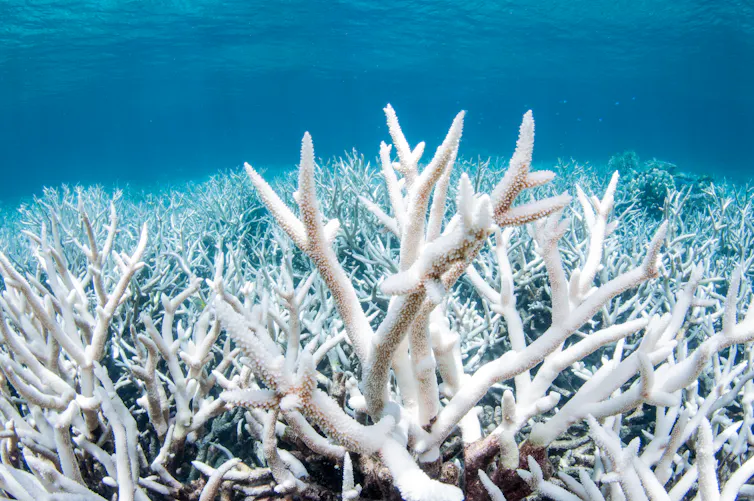
White bleached coral in a blue sea.
Bleached coral on the Great Barrier Reef outside Cairns. El Nino leads to warmer ocean temperatures that can trigger bleaching. Brett Munroe Garner/Getty

How is it affecting the world’s weather?

This historic El Niño is already altering weather around the globe.

We see its most direct and severe impacts in countries surrounding the Pacific Ocean. Indonesia, for example, just this month was battling massive wildfires. Scientists understand the current El Nino is a major driver of these increasingly fierce blazes.

El Niño is also reshaping how and where cyclones form. Satellite pictures reveal there are currently four active tropical cyclones in the Pacific, from near Japan to as far away as Hawaii. This is extremely unusual. El Niño typically boosts cyclone activity in the eastern and central Pacific by carrying warmer water to those regions. Usually we only see one or two such cyclones.

In Australia, we are slightly more removed from the effects of El Niño. However, we can expect to feel its presence more strongly as we head into spring.

The Bureau of Meteorology’s seasonal forecast suggests Australia has so far had a textbook response to El Niño. Temperatures are rising – up to an unseasonable 37°C this week in parts of northern Australia – and conditions are getting drier. Much of eastern and central Australia can expect an unusually dry spring and summer, potentially heightening bushfire risk.

However, a record-breaking El Niño will not necesssarily trigger catastrophic bushfires in Australia. Consider three of the last strong El Niño we’ve experienced. In 1982, a robust El Niño coincided with drought-like conditions. In contrast, during the El Niño years of 1997–98 and 2015–16, some parts of Australia received drenching rain while other regions barely registered any moisture.

What may lie ahead

The intensifying El Niño will likely exacerbate the consequences of climate change.

As El Niño strengthens, countries around the world will be forced to grapple with increasingly extreme weather. Tragically, the most disadvantaged will be the hardest hit, with nearly 50 million people in vulnerable communities likely to be pushed into acute hunger. Farmers across the globe face more unpredictable weather, from crop-destroying floods in South America to severe drought in parts of Africa.

To protect the world’s people and ecosystems, governments must invest in robust research. We urgently need more modelling capability to identify which regions will be worst affected by the strengthening El Niño. This is particularly true for Australia, where a lack of understanding of how climate change on top of a strong El Niño will affect local conditions.

This record-shattering El Niño is already compounding the destructive effects of climate change. But it may be just the catalyst we need to finally abandon fossil fuels and curb our world-warming emissions.The Conversation

Mandy Freund, Lecturer, Climate Science Geography, The University of Melbourne

This article is republished from The Conversation under a Creative Commons license. Read the original article.

Friday, 20 February 2026

Climate change - impact of changes in Earth's upper atmosphere


Dramatic changes in upper atmosphere are responsible for recent droughts and bushfires: new research

Pixabay/Pexels, CC BY
Milton Speer, University of Technology Sydney and Lance M Leslie, University of Technology Sydney

Over the past decade, southern Australia has suffered numerous extreme weather and climate events, such as record-breaking heatwaves, bushfires, two major droughts and even flash flooding.

While Australia has always had these disasters, our research reveals these new extremes are the result of dramatic climate-driven changes in the upper atmosphere above Australia.

Eight to ten kilometres above the ground, the fast-flowing jet stream air currents have shifted further southwards, dragging rain-bearing winter weather systems away from Australia’s southern coastline.

This means southern Australia has experienced at least 25% less annual rainfall and is currently gripped by a continuing drought. Our findings should be a wake-up call for governments, primary producers and residents of some of Australia’s largest cities: the hotter, drier weather is here to stay.

Drought in the south, wet in the east

Southern Australia comprises the coastal and adjacent areas in the south of the continent, stretching about 4,000 kilometres from Perth to east of Melbourne. This region is home to ten million people, or about 35% of Australia’s population.

The two most recent droughts in southern Australia were the Tinderbox drought, from 2017 to 2019, and the present drought, which has not been named. It began in 2023 and is continuing into February 2026.

Drought is primarily a meteorological, or weather-related, phenomenon. It is defined by intense rainfall deficiencies over three months or longer, which severely impact agricultural production, water supplies and ecosystems.

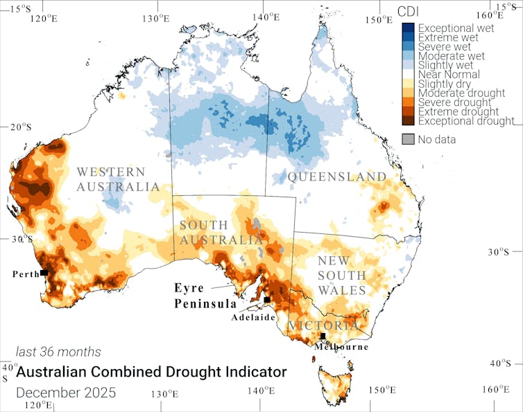
Notably, six of the past ten years were dry, tipping much of southern Australia into drought. In marked contrast, eastern Australia, including Sydney and Brisbane, experienced moderate to extreme wet conditions, including flash flooding. The map below shows drought in southern Australia in 2023–25.

A map of Australia showing areas of drought between 2023 to 2025.
CAPTION HERE. Australian Combined Drought Indicator Map, CC BY-ND

The meteorological factors that drive drought in southern Australia, and the shift from dry to wet conditions in eastern Australia, can be explained by shifts in the upper atmospheric jet streams. These are fast-flowing, narrow air currents high in the atmosphere, about 8–10km above Earth.

Major changes to the jet streams

Our research reveals dramatic changes to the jet streams in the Australian region, particularly in the past decade. Put simply, jet streams are fast-moving belts of westerly winds in the upper atmosphere. They steer cold fronts and low-pressure systems across southern Australia, from west to east, determining rainfall and temperature patterns.

In the Australian region there is a subtropical jetstream over northern Australia and a polar jet stream in the mid-latitude westerly winds south of Australia. Historically, the jetstreams have steered the rain-bearing systems over southern Australia.

We discovered the subtropical jet stream, which brings rainy weather systems, has shifted about 10 degrees of latitude (roughly 1,000km) southwards towards the pole, since 2015.

This shift has caused traditional rain-producing weather systems to track south of the continent, completely missing southern Australia. Our previous research comparing 1965 to 1992, and 1993 to 2020, also showed the jet streams had shifted towards Antarctica.

This shift is due to climate change from increased greenhouse gas emissions that continues to warm the oceans and atmosphere. As the world keeps warming, the jet streams will be pushed further poleward.

Hence the jet stream changes are responsible for both the current drought, and the Tinderbox Drought (2017–19). Each drought was caused by below-average winter rainfall from April to October. And the greatest relocation of Australian region jet streams occurred in the past decade.

Where were the droughts?

Between 2023 and 2025, almost all of southern Australia experienced a serious to extreme lack of rain, causing severe to exceptional drought conditions. Drought has affected Melbourne, Adelaide and Perth, straining existing water supplies.

Brief winter rainfall in July 2025 provided some local relief, however, the impact was short-lived. Recently, the summer months from December 2025 to February 2026 brought extreme heat and record low rainfall. Consequently, drought continues into January and February 2026. In striking contrast, parts of eastern and northern Australia received record rainfall and flash floods.

In southern Australian, coastal and inland areas, river systems and dams are experiencing greatly reduced water supplies. This reflects the continuing long-term impacts of global warming.

In Adelaide, three extremely dry years have reduced water inflows to reservoirs. The city’s single desalination plant quadrupled its output from January last year, to meet demand. Perth has experienced a long-term rainfall decline since 1970. It has two desalination plants and is building a third.

After briefly recovering during the La Niña years from 2021 to 2023, Melbourne’s dams are at their lowest levels since the Tinderbox Drought. Melbourne received well below average rainfall through to October 2025. Its desal plant was activated briefly in 2022, and was reactivated in April 2025. A second Melbourne plant is planned, but will take almost a decade to complete.

Primed to burn

Droughts and low winter rainfall means southern Australia is very susceptible to bushfire. Heatwaves and dry vegetation at the beginning of this summer brought catastrophic bushfire conditions, bolstered by dry, westerly wind changes. This caused catastrophic bushfires in southern Australia. More than 430,000 hectares have been burned in Victoria.

These conditions should be a jolting wakeup call. A possible El Niño, or warming climate pattern, later in 2026 is likely to worsen existing drought conditions in southern Australia. Melbourne’s water storage is at 70% capacity and is in danger of falling much lower. Southern Australia needs to ready itself for a hot, dry year.The Conversation

Milton Speer, Visiting Fellow, School of Mathematical and Physical Sciences, University of Technology Sydney and Lance M Leslie, Professor, School of Mathematical And Physical Sciences, University of Technology Sydney

This article is republished from The Conversation under a Creative Commons license. Read the original article.